Useful Products and Potential Applications
Useful Products
Channel migration mapping studies develop a variety of products, for example:
- River-based maps of several different channel migration zones (historic migration area, erosion hazard area, avulsion hazard area and restricted migration area also known as the disconnected migration area)
- A report for each mapped river detailing regional hydrology, geology, and geomorphology; methodology and analysis for the river; and a detailed listing of each channel migration site that can be used for doing site-specific assessments
- Historic river corridor imagery that has been spatially referenced and mosaicked for use in a Geographic Information System (GIS)
- GIS data including mapped bankline locations, reach breaks, migration vectors, and each of the Channel Migration Mapping boundaries
- Ancillary datasets such as physical features (rip rap, levees, diversions, etc.) that were either existing or generated for the project.
Potential Applications
Channel Migration Zone studies are designed to support a myriad of river corridor management applications (Figure 1). Often a primary objective is to generate a set of planning tools to help river managers, landowners, developers, and other interested entities make informed decisions on land use and river management. Channel migration mapping is a low-cost, scientifically-based methodology for defining the areas at risk of river occupation due to migration (the constant process of a channel moving laterally across a floodplain due to erosion) and/or avulsion (the rapid and often catastrophic relocation of a stream channel and the abandonment of the existing channel). Montana has no regulatory requirements for the applications of channel migration mapping.
Potential uses for CMZ projects include the following:
- Proactively identify future problem areas through documentation of active bankline migration;
- Identify restoration opportunities where bank armor has restricted the natural Channel Migration Zone;
- Provide a background tool to assess channel dynamics within any given area;
- Assist in the development of river corridor best management practices;
- Improve stakeholder understanding of the geomorphic behavior of this river system;
- Support planning decisions at local and county levels by identifying relative levels of erosion risk (such as the Yellowstone River Pipeline Risk Assessement and itsAddendum;
- Identify areas where channel migration easements would be appropriate;
- Facilitate productive discussion between regulatory, planning, and development interests active within the river corridor; and,
- Help define long-term sustainable river corridor boundaries.
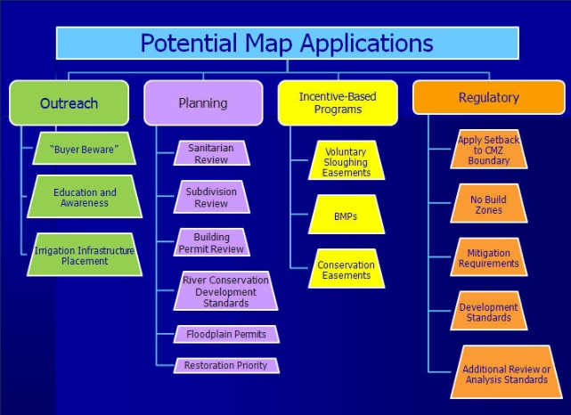
Figure 1. Potential applications of channel migration mapping studies. Image provided by Applied Geomorphology and DTM Consulting.
Montana Channel Migration Links
- Montana Channel Migration Home
- Projects
- Beaverhead River
- Big Hole River
- Bighorn River
- Clark Fork - Bitterroot to Huson
- Clark Fork - Plains Area
- Clark Fork and Bitterroot Rivers
- Deep Creek
- East Gallatin River
- Flathead River - Old Steel Bridge to Flathead Lake
- Gallatin River
- Jefferson River
- Madison River
- Musselshell River - Roundup
- Prickly Pear and Lower Tenmile Creeks
- Lower Ruby River
- Ruby - Clear Creek
- Sun River
- Yellowstone River
- Data, Maps, and Reports
- Useful Products and Potential Applications
- GIS Data Deliverables
- Uncertainty and Risk
- Guidelines and Best Practices
- Contacts
- Resources
