Physical Feature Inventory Data
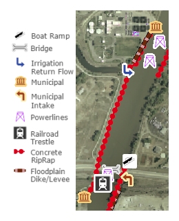 Physical Feature Inventories are a record of the development of flood and erosion control structures over time. They also contain features such as diversion structures and irrigation return flow points.
- 2015 Inventory. This is the 2011 inventory with updates for Reed Point to Custer only, based on high-resolution 2015 aerial photos.
- 2011 Inventory. This is a revision of the 1999-2001 inventories, based on high-resolution 2011 aerial photos.
- 1999-2001 Inventories. This is a combination of an inventory of the river done from 1999 aerial photos of Park County and a field inventory of the remaining counties performed in 2001.
Historic Physical Feature Inventories
- 1954 (Park County)
- 1973 (Park County)
- 1950, 1976, 1995, and 2005 (Yellowstone, Stillwater, and Dawson Counties, in ESRI personal geodatabase format)
Yellowstone Clearinghouse Home
Yellowstone River Final Reports
- Cumulative Effects Analysis (CEA)
- CEA Technical Appendices
- CEA Executive Summary
- Reach Narratives
- Recommended Practices and Position Statements
- Governor's Upper Yellowstone Task Force (1997-2003)
Maps
- Online Map Viewer
- Reach Story Map 1: Overview
- Reach Story Map 2: Details
- Yellowstone Reference Maps
- Maps Selected from Technical Reports
Data and Technical Reports
- Imagery and Topographic Mapping
- Hydrology and Hydraulics
- Land Use and Physical Features
- Geomorphology
- Biology
- Socioeconomics
- List of Available GIS Data
Contact Info
