CadNSDI Montana
Data and Documentation
Montana PLSS CadNSDI Data Download
The CadNSDI represents the cadastral components of the Public Land Survey System (PLSS). Generally published annually, the data are provided as geodatabase and shapefile formats in the NAD 83 (2011) projection. Previous publications of the CadNSDI are available as Related Records.
Public Land Survey System Web Map Service
The Montana Public Land Survey System comprises townships, sections, section subdivisions, and special surveys.
A handbook for GIS users of the CadNSDI Publication data set published by the FGDC Cadastral Subcommittee PLSS Work Group.
A discussion site for national parcel and cadastral data to support the Cadastral NSDI.
Federal Records Database Land Records
The national historic database of federal land-use records including surveys, patents, and master title plats and is maintained by the Bureau of Land Management Land Records.
The BLM Geospatial Business Platform Hub is a public ArcGIS-based platform for exploring, viewing, and downloading Bureau of Land Management geospatial data across national and state programs.
About
CadNSDI Montana is the current, authoritative source for the most accurate GIS representation of the PLSS. The name “CadNSDI” comes from the FGDC’s Cadastral Subcommittee. In the spring of 2014, the Montana State Library (MSL) assumed the management and publication of the Montana CadNSDI. In partnership with MSL and Premier Data Services, Inc., the Bureau of Land Management (BLM) continues its stewardship of the Montana CadNSDI on federal lands.
Improvements to the CadNSDI
The CadNSDI is published with new adjustments on an annual basis according to FGDC Cadastral Publication Standards. It makes use of Montana’s Mapping Control Framework as the basis of its coordinates in areas where mapping control is available. Grants are available from the Montana Geospatial Information Act grant program to collect survey control to be used in future CadNSDI adjustments. The Mapping Control theme lead accepts survey control on an ongoing basis, and if applicable, this control will be used in future adjustments to improve the accuracy of the CadNSDI.
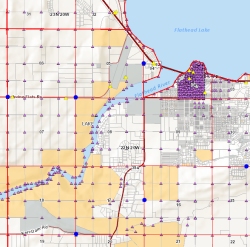
The CadNSDI supports the development of Montana’s Cadastral Framework, Administrative Boundaries Framework, and other Montana framework datasets built upon the PLSS geography. Below is an example of improved Cadastral parcel data following an adjustment of the CadNSDI in that area.
Applications
Explore completed areas of adjustment, learn about how the CadNSDI is adjusted, and discover how other datasets rely on its accuracy (currently, unavailable, a new application is being built).
The map (currently, unavailable, a new map is being built) below shows Public Land Survey townships in Montana where CadNDSI accuracy improvements have been proposed, are in progress, or have been completed, as well as where mapping control is available. Improvements to the CadNSDI occur through adjustments using survey control data. To contribute survey control to be used in future adjustments or to propose a new area for adjustment, email geoinfo@mt.gov.
Theme Lead
Jeff Hedstrom
Montana State Library
jhedstrom@mt.gov
(406) 444-5371